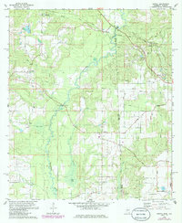
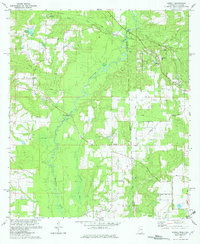
1982 Map of Howell
USGS Topo · Published 1986About this map
The Es Catawpa River winds through this borderland region, defining the landscape between George County, Mississippi, and Mobile County, Alabama. During the early 1980s, this area maintained a rural character shaped by a network of local roads such as Moody Loop Rd and Ferry Road. The settlement of Howell serves as a central point near the Howell Bridge, while the Illinois Central Gulf railroad line cuts through the northern reaches near Latonia and Moffet. Genealogy researchers will find significant value in the numerous documented burial sites, including the Moffetville Cem and Ward Cem, alongside local congregations like Palestine Ch and Midway Ch. The presence of several sandpits and the Natchez Trace roadbed further illustrate the local industry and historical transportation routes of the deep South during this era.
Find a feature on this map
38 named features on this map. Tap any name to fly to it.
Don’t see what you’re looking for? This feature index may not catch every label — zoom into the map to look around manually.
Map Details
Editions of this 1982 Howell Map
2 editions found
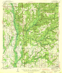
Other maps of this area

1941 · Hurley
USGS Topo · 1:62,500

1941 · Vancleave
USGS Topo · 1:62,500

1941 · Lucedale
USGS Topo · 1:62,500

1942 · Wilmer
USGS Topo · 1:62,500

1943 · Lucedale
USGS Topo · 1:62,500
1943 · Hurley
USGS Topo · 1:62,500

1943 · Vancleave
USGS Topo · 1:62,500

1944 · Wilmer
USGS Topo · 1:62,500

1944 · Vancleave
USGS Topo · 1:62,500

1953 · Mobile
USGS Topo · 1:250,000