
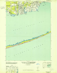
1947 Map of Howells Point
USGS Topo · Published 1947About this map
The coastal interface of Long Island's South Shore is captured here just after the war, showcasing the residential clusters of Brookhaven near the mouth of Howell Creek. This 1947 revision, based on 1942 aerial photography, documents the narrow, unprotected expanse of Great South Beach as it buffers the mainland from the Atlantic Ocean. The map provides a high-resolution view of the shifting sandbars and marshy outcrops within the estuarine waters, including Ridge Island and Pelican Island situated between Bellport Bay and the open sea. This era of surveying predates much of the modern stabilization of the barrier beach system, reflecting a more fluid landscape of inlets and coves like Long Cove. The detail focuses heavily on the hydrography and shoreline morphology, essential for navigating the shallow reaches of Great South Bay and Patchogue Bay at Howell Pt.
Find a feature on this map
11 named features on this map. Tap any name to fly to it.
Don’t see what you’re looking for? This feature index may not catch every label — zoom into the map to look around manually.
Map Details
Editions of this 1947 Howells Point Map
This is the sole edition of this map. No revisions or reprints were ever made.
Other maps of this area

1902 · Setauket
USGS Topo · 1:62,500

1902 · Fire Island
USGS Topo · 1:62,500

1903 · Fire Island
USGS Topo · 1:62,500

1904 · Setauket
USGS Topo · 1:62,500

1904 · Islip
USGS Topo · 1:125,000

1904 · Moriches
USGS Topo · 1:62,500

1919 · Setauket
USGS Topo · 1:62,500

1942 · Islip
USGS Topo · 1:125,000

1947 · Bellport
USGS Topo · 1:24,000
1947 · Sayville
USGS Topo · 1:24,000