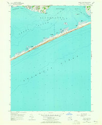
1956 Map of Howells Point
USGS Topo · Published 1965About this map
Fire Island Beach stretches across the center of this mid-1950s coastal survey, separating the Atlantic Ocean from the quiet waters of the Great South Bay. The map provides a detailed look at the maritime geography of the Town of Brookhaven, where the barrier island is punctuated by small landmarks like Whalehouse Point and the Lookout Tower. On the mainland, the residential layout of Bellport and Shirley is visible, showing the early suburban development near the marshy mouths of Hedges Cr and Howell Creek. This period precedes significant coastal changes, documenting a system of small islands such as John Boyle Island and Pelican Island within Bellport Bay. The presence of a Boardwalk near Hospital Island suggests the area's established role as a seasonal destination for Long Island residents.
Find a feature on this map
25 named features on this map. Tap any name to fly to it.
Don’t see what you’re looking for? This feature index may not catch every label — zoom into the map to look around manually.
Map Details
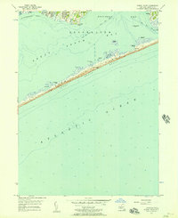
Editions of this 1956 Howells Point Map
2 editions found
Other maps of this area

1902 · Setauket
USGS Topo · 1:62,500

1902 · Fire Island
USGS Topo · 1:62,500

1903 · Fire Island
USGS Topo · 1:62,500

1904 · Setauket
USGS Topo · 1:62,500

1904 · Islip
USGS Topo · 1:125,000

1904 · Moriches
USGS Topo · 1:62,500

1919 · Setauket
USGS Topo · 1:62,500

1942 · Islip
USGS Topo · 1:125,000

1947 · Bellport
USGS Topo · 1:24,000

1947 · Howells Point
USGS Topo · 1:24,000