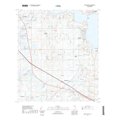
2018 Map of Howey-in-the-Hills
USGS Topo · Published 2018About this map
Howey-in-the-Hills and Groveland anchor this landscape of the central Florida ridge, where countless lakes and wetlands dictate the pattern of human settlement. The map reveals a transition between established lakeside communities and the intricate hydrography of the interior, featuring named bodies of water like Lake Harris, Pumpkin Center Lake, and the winding Palatlakaha River. Road networks such as Co RD 48 and various local thoroughfares connect smaller settlements like Pumpkin Center and Orange Blossom to the larger centers of Mascotte and Leesburg at the map's edge.
Find a feature on this map
174 named features on this map. Tap any name to fly to it.
Don’t see what you’re looking for? This feature index may not catch every label — zoom into the map to look around manually.
Map Details
Editions of this 2018 Howey-in-the-Hills Map
This is the sole edition of this map. No revisions or reprints were ever made.
Other maps of this area

1955 · Orlando
USGS Topo · 1:250,000

1957 · Orlando
USGS Topo · 1:250,000

1958 · Orlando
USGS Topo · 1:250,000

1962 · Orlando
USGS Topo · 1:250,000

1962 · Clermont East
USGS Topo · 1:24,000

1962 · Astatula
USGS Topo · 1:24,000

1965 · Leesburg East
USGS Topo · 1:24,000

1966 · Leesburg West
USGS Topo · 1:24,000
1966 · Eustis
USGS Topo · 1:24,000
1969 · Center Hill
USGS Topo · 1:24,000