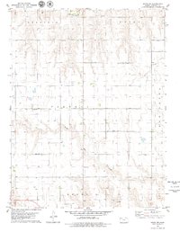
1979 Map of Hoxie NW
USGS Topo · Published 1979About this map
South Fk Solomon River and Bow Creek define this agricultural landscape of Sheridan County during the late 1970s. The map illustrates a meticulously organized section of the High Plains, where the townships of Sheridan, Union, Parnell, and Kenneth meet. Central to the rural community is Immanuel Ch, serving as a social and spiritual anchor amidst the sprawling fields. Local industry is marked by several excavations, including a Gravel Pit in the north and a Sandpit in the south, while a Radio Tower stands as a modern landmark. An interesting technical detail included in this survey is the notation of fine red dashed lines, which trace selected fence and field lines as they appeared on aerial photographs from 1974.
Find a feature on this map
14 named features on this map. Tap any name to fly to it.
Don’t see what you’re looking for? This feature index may not catch every label — zoom into the map to look around manually.
Map Details
Editions of this 1979 Hoxie NW Map
This is the sole edition of this map. No revisions or reprints were ever made.
Other maps of this area

1951 · Selden
USGS Topo · 1:62,500

1954 · Goodland
USGS Topo · 1:250,000

1956 · Goodland
USGS Topo · 1:250,000

1957 · Goodland
USGS Topo · 1:250,000

1978 · Allison
USGS Topo · 1:24,000

1978 · Selden
USGS Topo · 1:24,000

1978 · Dresden South
USGS Topo · 1:24,000

1979 · Hoxie
USGS Topo · 1:24,000

1979 · Hoxie NE
USGS Topo · 1:24,000
1979 · Rexford NE
USGS Topo · 1:24,000