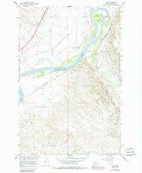
1967 Map of Hoyt
USGS Topo · Published 1985About this map
The Yellowstone River cuts a wide, braided path through this portion of Dawson County, Montana, defining a landscape shaped by both natural drainage and human engineering. In the mid-1960s, the small settlement of Hoyt sat along the Burlington Northern railroad line, serving as a quiet point of activity south of the river. The topography is marked by a complex system of coulees and drainages including Clear Creek, Cedar Creek, and Cabin Creek, while the Main Canal demonstrates the critical role of water management in the region's agricultural development.
Find a feature on this map
13 named features on this map. Tap any name to fly to it.
Don’t see what you’re looking for? This feature index may not catch every label — zoom into the map to look around manually.
Map Details
Editions of this 1967 Hoyt Map
2 editions found
Other maps of this area

1909 · Glendive
USGS Topo · 1:250,000

1953 · Miles City
USGS Topo · 1:250,000

1954 · Glendive
USGS Topo · 1:250,000

1957 · Miles City
USGS Topo · 1:250,000

1957 · Glendive
USGS Topo · 1:250,000

1958 · Miles City
USGS Topo · 1:250,000

1958 · Glendive
USGS Topo · 1:250,000

1966 · Marsh SW
USGS Topo · 1:24,000

1967 · Marsh
USGS Topo · 1:24,000

1967 · Hoyt
USGS Topo · 1:24,000