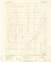
1951 Map of Hoyt
USGS Topo · Published 1951About this map
Hoyt stands as the central hub of this agricultural landscape along the border of Morgan and Adams Counties. Surveyed just after the war for the Department of the Interior's Missouri River Basin development program, the map documents a transition in rural land use. Irrigation and water management are prominent, evidenced by the Moore Reservoir No 1 and the USGS Testing and Recording Station located along the banks of Bijou Creek. The terrain is characterized by the broad, level Antelope Flats and several intermittent drainages like Antelope Creek and Rock Creek. Local social infrastructure is anchored by the Long Meadow Community Center and the Hoyt Cemetery, reflecting a scattered but connected farming community during the early 1950s.
Find a feature on this map
14 named features on this map. Tap any name to fly to it.
Don’t see what you’re looking for? This feature index may not catch every label — zoom into the map to look around manually.
Map Details
Editions of this 1951 Hoyt Map
2 editions found
Other maps of this area

1950 · Wiggins
USGS Topo · 1:24,000

1950 · Wiggins SW
USGS Topo · 1:24,000

1950 · Hoyt
USGS Topo · 1:24,000

1951 · Hoyt
USGS Topo · 1:24,000

1951 · Leader NW
USGS Topo · 1:24,000

1951 · Omar
USGS Topo · 1:24,000

1951 · Leader
USGS Topo · 1:24,000

1953 · Denver
USGS Topo · 1:250,000

1954 · Limon
USGS Topo · 1:250,000

1954 · Sterling
USGS Topo · 1:250,000