
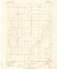
1951 Map of Hoyt
USGS Topo · Published 1951About this map
The settlement of Hoyt and its surrounding plains are documented here just as the post-war era brought specialized federal infrastructure to this section of the Colorado high plains. Situated along the boundary between Morgan Co and Adams Co, the area is defined by the ephemeral drainages of Bijou Creek and Antelope Creek, which carve through the wide Flats and past the distinctive rise of Bidwell Hill. This 1951 survey reveals a landscape transitioning from traditional ranching to include modern utilities and scientific study, evidenced by the USBR Substation and the USGS Testing and Recording Station. For those tracing local heritage, the map identifies centers of social life like the Long Meadow Community Center and the Hoyt Cemetery, providing essential coordinates for family history and the study of rural community networks during the mid-century.
Find a feature on this map
16 named features on this map. Tap any name to fly to it.
Don’t see what you’re looking for? This feature index may not catch every label — zoom into the map to look around manually.
Map Details
Editions of this 1951 Hoyt Map
2 editions found
Other maps of this area

1950 · Wiggins
USGS Topo · 1:24,000

1950 · Wiggins SW
USGS Topo · 1:24,000

1950 · Hoyt
USGS Topo · 1:24,000

1951 · Leader NW
USGS Topo · 1:24,000

1951 · Omar
USGS Topo · 1:24,000

1951 · Leader
USGS Topo · 1:24,000

1953 · Denver
USGS Topo · 1:250,000

1954 · Limon
USGS Topo · 1:250,000

1954 · Sterling
USGS Topo · 1:250,000

1954 · Greeley
USGS Topo · 1:250,000