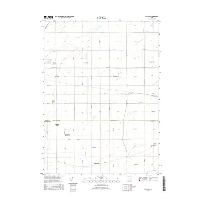
2016 Map of Hoytville
USGS Topo · Published 2016About this map
Hoytville serves as the central hub of this agricultural landscape in northwestern Ohio, situated at the junction of Otsego Pike and W Church St. The village is surrounded by a grid of township roads that cross numerous waterways, including the N Br Portage River and Needles Cr. To the west, the Baltimore and Ohio RR cuts across the corner of the map near the Deshler Municipal Landing Strip. The southern portion of the quadrangle highlights the small settlements of Hancock and Deweyville, illustrating the dispersed residential patterns typical of Wood and Hancock counties. Local landmarks such as Butlers Mill and cemeteries like Jackson Township Cem and Thomas Cem offer specific touchpoints for genealogical research and local history, marking the sites of earlier community infrastructure and family burials amidst the flat, fertile plains of the region.
Find a feature on this map
39 named features on this map. Tap any name to fly to it.
Don’t see what you’re looking for? This feature index may not catch every label — zoom into the map to look around manually.
Map Details
Editions of this 2016 Hoytville Map
This is the sole edition of this map. No revisions or reprints were ever made.
Other maps of this area

1901 · Bowling Green
USGS Topo · 1:62,500

1903 · Bowling Green
USGS Topo · 1:62,500

1903 · Findlay
USGS Topo · 1:62,500

1909 · Mc Clure
USGS Topo · 1:62,500

1956 · Toledo
USGS Topo · 1:250,000

1958 · Bowling Green South
USGS Topo · 1:24,000

1960 · Deshler
USGS Topo · 1:24,000

1960 · North Baltimore
USGS Topo · 1:24,000
1960 · Weston
USGS Topo · 1:24,000
1960 · Leipsic
USGS Topo · 1:24,000