
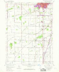
1958 Map of Bowling Green South
USGS Topo · Published 1960About this map
The agricultural landscape south of Bowling Green is defined by the flat expanse of the Plain and the subtle rise of the Sand Ridge. In the late 1950s, this region was a network of small crossroads settlements and family farms connected by the Baltimore and Ohio and New York Central railroads. The map captures the social hubs of these rural communities, featuring landmarks like the Mt Zion Ch, Westwood High Sch, and the Sargeant Cem.
Find a feature on this map
70 named features on this map. Tap any name to fly to it.
Don’t see what you’re looking for? This feature index may not catch every label — zoom into the map to look around manually.
Map Details
Editions of this 1958 Bowling Green South Map
2 editions found
Other maps of this area

1901 · Bowling Green
USGS Topo · 1:62,500

1903 · Bowling Green
USGS Topo · 1:62,500

1903 · Findlay
USGS Topo · 1:62,500

1909 · Mc Clure
USGS Topo · 1:62,500

1935 · Grand Rapids
USGS Topo · 1:24,000
1938 · Tontogany
USGS Topo · 1:31,680

1940 · Grand Rapids
USGS Topo · 1:31,680
1952 · Tontogany
USGS Topo · 1:24,000
1952 · Grand Rapids
USGS Topo · 1:24,000

1956 · Toledo
USGS Topo · 1:250,000