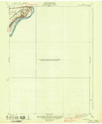
1938 Map of Tontogany
USGS Topo · Published 1938About this map
Waterville stands at a sharp bend in the Maumee River, serving as a focal point for transportation and industry in the late 1930s. The landscape is defined by the heavy infrastructure of the New York Chicago and St Louis and Toledo and Ohio Central railroads, which cross the river near Granger Island. Local commerce and resource extraction are evident at the Waterville Quarry, while the river itself is dotted with prominent landforms like Missionary Island. A notable historic landmark, Roche de Boeuf, sits along the riverbank just south of the main settlement. The presence of Canal Road and Napoleon Road hints at the evolving thoroughfares that once followed early trade routes along the river corridor between Lucas and Wood Counties.
Find a feature on this map
13 named features on this map. Tap any name to fly to it.
Don’t see what you’re looking for? This feature index may not catch every label — zoom into the map to look around manually.
Map Details
Editions of this 1938 Tontogany Map
2 editions found

Other maps of this area

1900 · Toledo
USGS Topo · 1:62,500

1901 · Bowling Green
USGS Topo · 1:62,500

1903 · Bowling Green
USGS Topo · 1:62,500

1909 · Mc Clure
USGS Topo · 1:62,500

1911 · Swanton
USGS Topo · 1:62,500

1914 · Swanton
USGS Topo · 1:62,500

1934 · Rossford
USGS Topo · 1:24,000

1935 · Grand Rapids
USGS Topo · 1:24,000

1935 · Whitehouse
USGS Topo · 1:24,000

1935 · Maumee
USGS Topo · 1:24,000