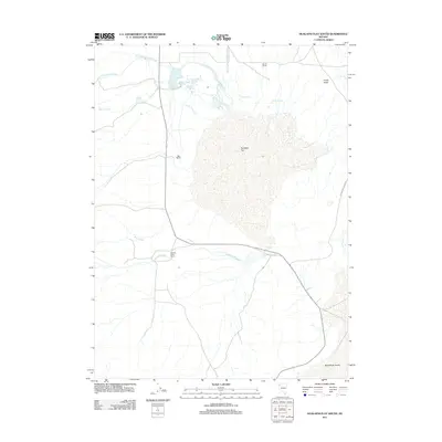
2011 Map of Hualapai Flat South
USGS Topo · Published 2011About this map
Geothermal activity and remote high-desert ranching define this portion of Washoe County in the early 21st century. The landscape is dominated by the expansive Hualapai Flat, a basin where water and heat emerge in concentrated spots like The Geyser, Wards Hot Spring, and Cottonwood Springs. These water sources sustain isolated agricultural outposts, including Fly Ranch and Granite Creek Ranch, which sit at the margins of the playa. To the north and west, drainage systems like Little Cottonwood Creek and Barker Creek flow toward the flat, while Finley Butte provides a rare point of elevation on the eastern horizon. The presence of Fly Reservoir and various spring clusters suggests a delicate management of water in an environment that transitions southward into the stark expanse of the Black Rock Desert.
Find a feature on this map
19 named features on this map. Tap any name to fly to it.
Don’t see what you’re looking for? This feature index may not catch every label — zoom into the map to look around manually.
Map Details
Editions of this 2011 Hualapai Flat South Map
This is the sole edition of this map. No revisions or reprints were ever made.
Other maps of this area

1886 · Granite Range
USGS Topo · 1:250,000

1894 · Granite Range
USGS Topo · 1:250,000

1955 · Lovelock
USGS Topo · 1:250,000

1959 · Lovelock
USGS Topo · 1:250,000

1964 · Gerlach
USGS Topo · 1:62,500

1980 · Dry Mountain NW
USGS Topo · 1:24,000

1980 · Melody Mountain
USGS Topo · 1:24,000
1980 · The Banjo
USGS Topo · 1:24,000
1980 · Hualapai Flat North
USGS Topo · 1:24,000
1980 · Mormon Dan Peak
USGS Topo · 1:24,000