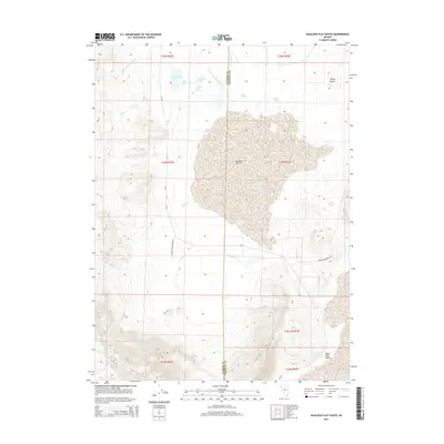
2014 Map of Hualapai Flat South
USGS Topo · Published 2014About this map
Hualapai Flat dominates this high-desert basin along the border of Washoe and Pershing Counties, defined by its complex geothermal and hydrologic network. The landscape is marked by unique features such as The Geyser and Wards Hot Spring, which indicate the active subterranean thermal activity characteristic of this region. To the north, Fly Reservoir collects runoff from the surrounding drainages, including Little Cottonwood Cr and Cottonwood Cr. The eastern edge of the map begins its transition into the vast Black Rock Desert, while the western terrain rises toward the ridges above Barker Cr. Accessibility is primarily provided by Granite Creek Ranch Rd and Soldier Meadows Rd, which connect the scattered water sources like Goose Springs and South Springs across the arid basin floor.
Find a feature on this map
26 named features on this map. Tap any name to fly to it.
Don’t see what you’re looking for? This feature index may not catch every label — zoom into the map to look around manually.
Map Details
Editions of this 2014 Hualapai Flat South Map
This is the sole edition of this map. No revisions or reprints were ever made.
Other maps of this area

1886 · Granite Range
USGS Topo · 1:250,000

1894 · Granite Range
USGS Topo · 1:250,000

1955 · Lovelock
USGS Topo · 1:250,000

1959 · Lovelock
USGS Topo · 1:250,000

1964 · Gerlach
USGS Topo · 1:62,500

1980 · Dry Mountain NW
USGS Topo · 1:24,000

1980 · Melody Mountain
USGS Topo · 1:24,000
1980 · The Banjo
USGS Topo · 1:24,000
1980 · Hualapai Flat North
USGS Topo · 1:24,000
1980 · Mormon Dan Peak
USGS Topo · 1:24,000