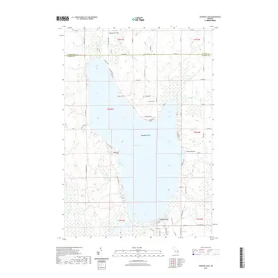
2019 Map of Hubbard Lake
USGS Topo · Published 2019About this map
Hubbard Lake dominates the landscape at the intersection of Alpena and Alcona counties, serving as a central geographic fixture for the surrounding lakeside communities. The shoreline is punctuated by several distinct landforms including Doctors Point, Churchill Point, and Hardwood Point, which define the lake's irregular shape and its various inlets like North Bay and Comstock Bay. On the northern shore, the Flowers Grave marker provides a unique point of interest for local historians, while the southern end is anchored by the settlement of Mt Maria and the recreational areas of Backus Beach and Larson Beach. The hydrological network feeding and draining the lake is well-represented, featuring Simmons Cr to the north and the West Branch River flowing from the south. The transition from forested terrain to residential lakeside development is evidenced by the dense grid of local roads, such as Hubbard Lake Rd and Mount Maria Rd, which link these small settlements.
Find a feature on this map
71 named features on this map. Tap any name to fly to it.
Don’t see what you’re looking for? This feature index may not catch every label — zoom into the map to look around manually.
Map Details
Editions of this 2019 Hubbard Lake Map
This is the sole edition of this map. No revisions or reprints were ever made.
Other maps of this area

1954 · Tawas City
USGS Topo · 1:250,000

1958 · Tawas City
USGS Topo · 1:250,000

1959 · Glennie
USGS Topo · 1:62,500

1959 · Harrisville
USGS Topo · 1:62,500

1971 · Spruce
USGS Topo · 1:24,000
1971 · Ossineke
USGS Topo · 1:24,000

1972 · Hubbard Lake
USGS Topo · 1:24,000

1972 · Hubbard Lake SW
USGS Topo · 1:24,000
1972 · Big Ravine Creek
USGS Topo · 1:24,000
1972 · Evans Creek
USGS Topo · 1:24,000