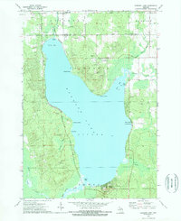
1972 Map of Hubbard Lake
USGS Topo · Published 1975About this map
Hubbard Lake dominates this northern Michigan landscape, where the waters of the Thunder Bay River flow north from the Lower reach. The 1972 topography illustrates a transition toward recreational development along the shoreline, particularly at Larson Beach on Comstock Bay and Backus Beach near the southern shore. A cluster of Ski Lifts and the prominent height of Mt Maria indicate the area's significance for winter sports, while older institutional roots are preserved in labels like Caledonia Sch and the Simmons locality.
Find a feature on this map
41 named features on this map. Tap any name to fly to it.
Don’t see what you’re looking for? This feature index may not catch every label — zoom into the map to look around manually.
Map Details
Editions of this 1972 Hubbard Lake Map
2 editions found
Other maps of this area

1954 · Tawas City
USGS Topo · 1:250,000

1958 · Tawas City
USGS Topo · 1:250,000

1959 · Glennie
USGS Topo · 1:62,500

1959 · Harrisville
USGS Topo · 1:62,500

1971 · Spruce
USGS Topo · 1:24,000
1971 · Ossineke
USGS Topo · 1:24,000

1972 · Hubbard Lake
USGS Topo · 1:24,000

1972 · Hubbard Lake SW
USGS Topo · 1:24,000
1972 · Big Ravine Creek
USGS Topo · 1:24,000
1972 · Evans Creek
USGS Topo · 1:24,000