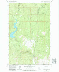
1964 Map of Hubbart Reservoir
USGS Topo · Published 1986About this map
The Hubbart Reservoir and its surrounding timberlands dominate this mid-century survey of the boundary between Flathead and Sanders Counties. Fed by the Little Bitterroot River, the reservoir features a notable spillway at its southern end, providing a vital water resource for the region's agricultural and industrial needs. The landscape is defined by the Flathead Nat For, where logging and resource extraction are indicated by features like the Flathead Sunset Quarry and the Hubbard Lookout station.
Find a feature on this map
19 named features on this map. Tap any name to fly to it.
Don’t see what you’re looking for? This feature index may not catch every label — zoom into the map to look around manually.
Map Details
Editions of this 1964 Hubbart Reservoir Map
2 editions found
Other maps of this area

1956 · Wallace
USGS Topo · 1:250,000

1957 · Kalispell
USGS Topo · 1:250,000

1960 · Kalispell
USGS Topo · 1:250,000

1960 · Wallace
USGS Topo · 1:250,000

1961 · Kalispell
USGS Topo · 1:250,000
1964 · Haskill Mountain
USGS Topo · 1:24,000

1964 · Mill Pocket Creek
USGS Topo · 1:24,000
1964 · Kofford Ridge
USGS Topo · 1:24,000

1964 · Hubbart Reservoir
USGS Topo · 1:24,000

1964 · Murr Peak
USGS Topo · 1:24,000