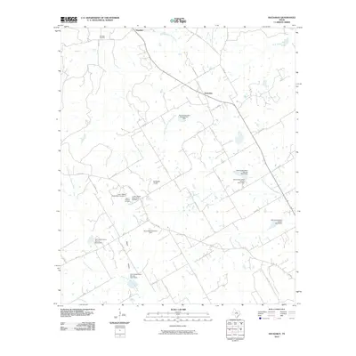
2010 Map of Huckabay
USGS Topo · Published 2010About this map
Huckabay and Hannibal center this Erath County landscape, which is defined by the headwaters of several prominent Texas river systems. The northern reaches are drained by the North Paluxy River and Barton Creek, while the southern half of the map features the branching headwaters of the Bosque River, including the North Fork North Bosque River and the South Fork North Bosque River. This area is heavily influenced by mid-century water management efforts, evidenced by a dense network of Soil Conservation Service dams and private structures like the J and J Beyer Dairy Dam Number 1 and Mount Pleasant Dairy Dam.
Find a feature on this map
54 named features on this map. Tap any name to fly to it.
Don’t see what you’re looking for? This feature index may not catch every label — zoom into the map to look around manually.
Map Details
Editions of this 2010 Huckabay Map
This is the sole edition of this map. No revisions or reprints were ever made.
Other maps of this area

1890 · Stephenville
USGS Topo · 1:125,000

1920 · Stephenville
USGS Topo · 1:125,000

1954 · Abilene
USGS Topo · 1:250,000

1958 · Abilene
USGS Topo · 1:250,000

1961 · Knob Hill
USGS Topo · 1:24,000

1961 · Stephenville
USGS Topo · 1:24,000

1965 · Huckabay SW
USGS Topo · 1:24,000

1965 · Lingleville
USGS Topo · 1:24,000
1965 · Bunyan
USGS Topo · 1:24,000
1965 · Reddy Mountain
USGS Topo · 1:24,000