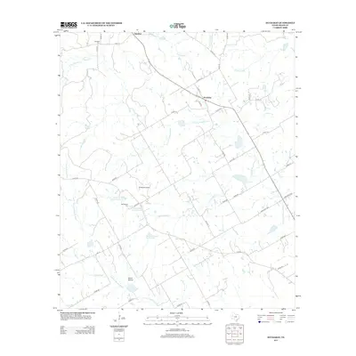
2012 Map of Huckabay
USGS Topo · Published 2012About this map
Huckabay stands as the central settlement in this Erath County landscape, positioned where several rural routes converge near the upper reaches of the N Fork N Bosque River. The area is characterized by its agricultural roots, evidenced by dairy operations like the Mount Pleasant Dairy Pond and the J and J Dairy Pond Number 2. For those tracing local history, the map preserves the locations of the Hannibal Cem near the northern settlement of Hannibal and the Mt Pleasant Cem further south. The drainage patterns are intricate, with the N Paluxy River and Scarborough Cr carving through the terrain. A mix of county roads and farm-to-market routes like Farm Road 3025 and FM-219 link these scattered homesteads and the small community at Wood Hollow.
Find a feature on this map
53 named features on this map. Tap any name to fly to it.
Don’t see what you’re looking for? This feature index may not catch every label — zoom into the map to look around manually.
Map Details
Editions of this 2012 Huckabay Map
This is the sole edition of this map. No revisions or reprints were ever made.
Other maps of this area

1890 · Stephenville
USGS Topo · 1:125,000

1920 · Stephenville
USGS Topo · 1:125,000

1954 · Abilene
USGS Topo · 1:250,000

1958 · Abilene
USGS Topo · 1:250,000

1961 · Knob Hill
USGS Topo · 1:24,000

1961 · Stephenville
USGS Topo · 1:24,000

1965 · Huckabay SW
USGS Topo · 1:24,000

1965 · Lingleville
USGS Topo · 1:24,000
1965 · Bunyan
USGS Topo · 1:24,000
1965 · Reddy Mountain
USGS Topo · 1:24,000