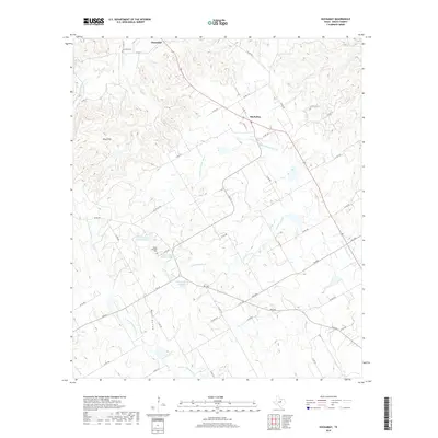
2019 Map of Huckabay
USGS Topo · Published 2019About this map
Huckabay and Hannibal center this Erath County landscape, which is defined by the complex headwaters of several prominent Texas river systems. The northern reaches of the N Fork N Bosque River and S Fork N Bosque River carve through the terrain, while the N Paluxy River emerges in the northeast. This 2019 survey documents a rural ranching and dairy economy, evidenced by named features like the Mount Pleasant Dairy Pond and the J and J Beyer Pond Number 1. Historical continuity is preserved at the Hannibal Cem and Mount Pleasant Cem, which serve as landmarks for genealogists and local historians. The varied elevation is most distinct at the Blue Hills and within the recesses of Wood Hollow, where numerous small tributaries like Scarborough Cr and Lost Cr feed into the larger forks of the Bosque.
Find a feature on this map
58 named features on this map. Tap any name to fly to it.
Don’t see what you’re looking for? This feature index may not catch every label — zoom into the map to look around manually.
Map Details
Editions of this 2019 Huckabay Map
This is the sole edition of this map. No revisions or reprints were ever made.
Other maps of this area

1890 · Stephenville
USGS Topo · 1:125,000

1920 · Stephenville
USGS Topo · 1:125,000

1954 · Abilene
USGS Topo · 1:250,000

1958 · Abilene
USGS Topo · 1:250,000

1961 · Knob Hill
USGS Topo · 1:24,000

1961 · Stephenville
USGS Topo · 1:24,000

1965 · Huckabay SW
USGS Topo · 1:24,000

1965 · Lingleville
USGS Topo · 1:24,000
1965 · Bunyan
USGS Topo · 1:24,000
1965 · Reddy Mountain
USGS Topo · 1:24,000