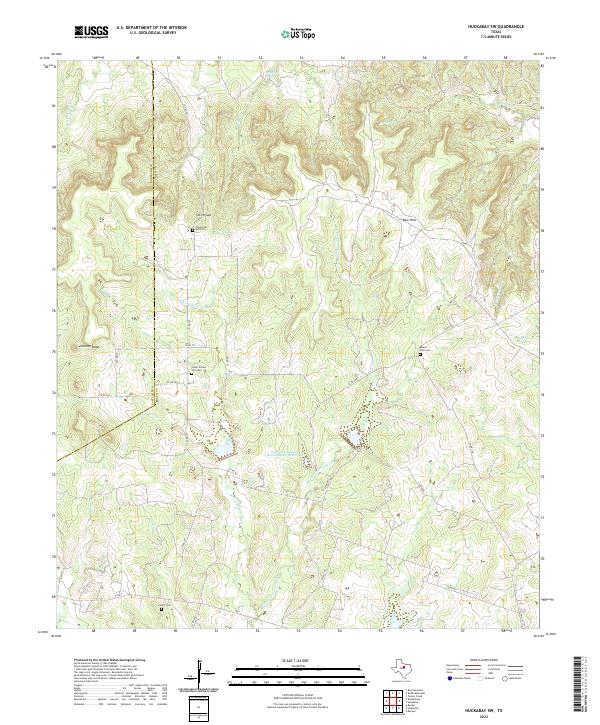
2022 Map of Huckabay SW
USGS Topo · Published 2022About this map
Smith Gap and the Blue Hills define the upland terrain of this Erath County landscape, where the headwaters of numerous creeks begin their descent through the Texas Cross Timbers. The area is characterized by a high density of small, family-named watercourses such as Red Fork Rush Cr and W Fork Armstrong Cr, which dictate the placement of local thoroughfares like Co RD 397. This map is particularly valuable for genealogical research, documenting several distinct burial grounds including Old School Hill Cem, Lower School Hill Cem, and Mount Zion Cem. These sites, along with landmarks like Dripping Spring and the Jameson Peaks, reflect a long-established rural community structure. The lower portion of the sheet shows the transition into more modern infrastructure with Soil Conservation Service Site 3 Reservoir and the path of W FM 8 near Lowell Cem.
Find a feature on this map
35 named features on this map. Tap any name to fly to it.
Don’t see what you’re looking for? This feature index may not catch every label — zoom into the map to look around manually.
Map Details
Editions of this 2022 Huckabay SW Map
This is the sole edition of this map. No revisions or reprints were ever made.
Other maps of this area

1890 · Stephenville
USGS Topo · 1:125,000

1894 · Eastland
USGS Topo · 1:125,000

1920 · Stephenville
USGS Topo · 1:125,000

1954 · Abilene
USGS Topo · 1:250,000

1958 · Abilene
USGS Topo · 1:250,000

1965 · Huckabay SW
USGS Topo · 1:24,000

1965 · Lingleville
USGS Topo · 1:24,000
1965 · Bunyan
USGS Topo · 1:24,000
1965 · Reddy Mountain
USGS Topo · 1:24,000
1965 · Huckabay
USGS Topo · 1:24,000