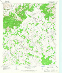
1965 Map of Huckabay
USGS Topo · Published 1967About this map
The Blue Hills rise above the agricultural and ranching terrain of Erath County in the mid-1960s, defining a landscape where narrow creek valleys give way to elevated plateaus. The North Fork Bosque River and its many tributaries, including Scarborough Creek and Hannibal Creek, have carved out a complex drainage network that dictated early settlement patterns. Small communities like Hannibal and Huckabay serve as the primary hubs, with many homesteads and properties organized around the undulating terrain of Wood Hollow and the surrounding heights.
Find a feature on this map
18 named features on this map. Tap any name to fly to it.
Don’t see what you’re looking for? This feature index may not catch every label — zoom into the map to look around manually.
Map Details
Editions of this 1965 Huckabay Map
2 editions found
Other maps of this area

1890 · Stephenville
USGS Topo · 1:125,000

1920 · Stephenville
USGS Topo · 1:125,000

1954 · Abilene
USGS Topo · 1:250,000

1958 · Abilene
USGS Topo · 1:250,000

1961 · Knob Hill
USGS Topo · 1:24,000

1961 · Stephenville
USGS Topo · 1:24,000

1965 · Huckabay SW
USGS Topo · 1:24,000

1965 · Lingleville
USGS Topo · 1:24,000
1965 · Bunyan
USGS Topo · 1:24,000
1965 · Reddy Mountain
USGS Topo · 1:24,000