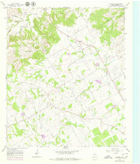
1965 Map of Huckabay
USGS Topo · Published 1979About this map
Huckabay and Hannibal center this study of Erath County, Texas, where the landscape transitions between the rolling Blue Hills and the fertile valleys of several branching water systems. The map details the drainage divide between the North Fork Paluxy River and the North Fork Bosque River, illustrating a rural economy defined by cattle ranching and resource extraction. Evidence of local industry is visible through numerous Gravel Pits and a Gas Well scattered across the terrain.
Find a feature on this map
19 named features on this map. Tap any name to fly to it.
Don’t see what you’re looking for? This feature index may not catch every label — zoom into the map to look around manually.
Map Details
Editions of this 1965 Huckabay Map
2 editions found
Other maps of this area

1890 · Stephenville
USGS Topo · 1:125,000

1920 · Stephenville
USGS Topo · 1:125,000

1954 · Abilene
USGS Topo · 1:250,000

1958 · Abilene
USGS Topo · 1:250,000

1961 · Knob Hill
USGS Topo · 1:24,000

1961 · Stephenville
USGS Topo · 1:24,000

1965 · Huckabay SW
USGS Topo · 1:24,000

1965 · Lingleville
USGS Topo · 1:24,000
1965 · Bunyan
USGS Topo · 1:24,000
1965 · Reddy Mountain
USGS Topo · 1:24,000