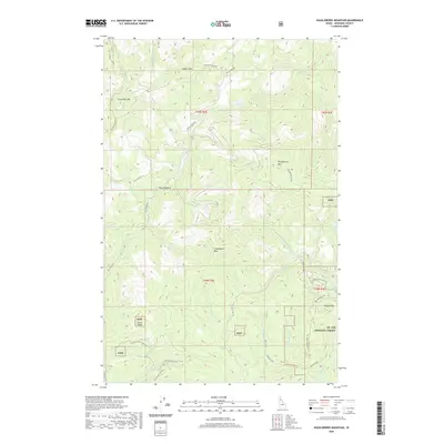
2020 Map of Huckleberry Mountain
USGS Topo · Published 2020About this map
St. Joe National Forest dominates this section of Shoshone County, revealing a landscape defined by its high-altitude peaks and the intricate drainage basins of the Mica and Marble Creek systems. High points such as Evergreen Mtn, Huckleberry Mtn, and Coddington Peak dictate the orientation of the surrounding forest roads. The map highlights a modern shift toward recreational land use, specifically for off-highway vehicles, as seen in the development of the Little Bear Creek Ohv and Norton Creek Ohv trails. Smaller geographical landmarks like Mica Meadows and Tylers Ridge provide specific reference points for those studying the local topography. The extensive network of Forest Service routes, including Evergreen Ridge Rd and Mica Creek Rd, traces the ridges and valleys once primarily utilized for timber management and fire access in this part of northern Idaho.
Find a feature on this map
78 named features on this map. Tap any name to fly to it.
Don’t see what you’re looking for? This feature index may not catch every label — zoom into the map to look around manually.
Map Details
Editions of this 2020 Huckleberry Mountain Map
This is the sole edition of this map. No revisions or reprints were ever made.
Other maps of this area

1955 · Spokane
USGS Topo · 1:250,000

1957 · Calder
USGS Topo · 1:62,500

1957 · St. Joe
USGS Topo · 1:62,500

1958 · Spokane
USGS Topo · 1:250,000

1961 · Fernwood
USGS Topo · 1:62,500

1969 · Marble Mountain
USGS Topo · 1:24,000

1969 · Grandmother Mtn
USGS Topo · 1:24,000
1969 · Merry Creek
USGS Topo · 1:24,000

1969 · Huckleberry Mtn
USGS Topo · 1:24,000

1981 · St Maries
USGS Topo · 1:100,000