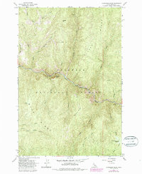
1963 Map of Huddleson Bluff
USGS Topo · Published 1987About this map
Nez Perce National Forest surrounds the winding South Fork Clearwater River in this 1960s study, later updated with 1980s aerial data. The terrain is defined by dramatic elevation changes between Rainbold Ridge and the river valley below, where Huddleson Bluff stands as a prominent landmark. A single Mine label along the river corridor points to the area's resource extraction history, while the secluded Lower Twentymile Meadows provides a rare break in the timbered slopes. This area is characterized by an extensive drainage system, where dozens of named tributaries like Peasley Creek and Twentymile Creek cut deep through Blue Ridge and Silver Ridge. The map documents the primitive road network and forest service infrastructure as it existed before late-20th-century developments, preserving the nomenclature of the backcountry including Bear Springs and Cougar Mtn.
Find a feature on this map
26 named features on this map. Tap any name to fly to it.
Don’t see what you’re looking for? This feature index may not catch every label — zoom into the map to look around manually.
Map Details
Editions of this 1963 Huddleson Bluff Map
3 editions found
Other maps of this area

1931 · Buffalo Hump
USGS Topo · 1:125,000

1934 · Buffalo Hump
USGS Topo · 1:125,000

1956 · Elk City
USGS Topo · 1:250,000

1960 · Elk City
USGS Topo · 1:250,000

1962 · Golden
USGS Topo · 1:24,000

1962 · Pilot Knob
USGS Topo · 1:24,000

1963 · Sourdough Peak
USGS Topo · 1:24,000

1963 · Huddleson Bluff
USGS Topo · 1:24,000
1963 · Hungry Ridge
USGS Topo · 1:24,000
1963 · Corral Hill
USGS Topo · 1:24,000