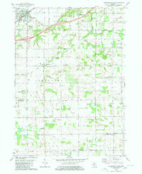
1980 Map of Hudsonville East
USGS Topo · Published 1980About this map
Hudsonville and the surrounding townships of Georgetown and Jamestown reveal a landscape transitioning from rural agricultural roots to suburban expansion in the mid-1970s. The Chesapeake and Ohio railroad corridor anchors the northern section, while the southern reaches near New Salem and North Dorr sit atop a significant Oil and Gas Field. This industrial presence contrasts with the numerous local landmarks that define the area's social history, including several parish centers like St Marys Ch and St Sebastian Ch.
Find a feature on this map
52 named features on this map. Tap any name to fly to it.
Don’t see what you’re looking for? This feature index may not catch every label — zoom into the map to look around manually.
Map Details
Editions of this 1980 Hudsonville East Map
This is the sole edition of this map. No revisions or reprints were ever made.
Other maps of this area

1914 · Grand Rapids
USGS Topo · 1:62,500

1943 · Grand Rapids
USGS Topo · 1:62,500

1958 · Allendale
USGS Topo · 1:24,000

1958 · Allegan
USGS Topo · 1:62,500

1958 · Grandville
USGS Topo · 1:62,500

1958 · Grandville
USGS Topo · 1:24,000

1958 · Grand Rapids
USGS Topo · 1:250,000

1959 · Wayland
USGS Topo · 1:62,500

1961 · Grand Rapids
USGS Topo · 1:250,000

1962 · Grand Rapids
USGS Topo · 1:250,000