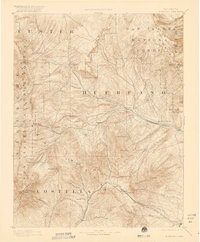
1892 Map of Huerfano Park
USGS Topo · Published 1920About this map
Blanca Peak anchors the southwestern corner of this topographic survey, which captures the high-altitude landscape of the Sangre de Cristo Mountains in the late nineteenth century. The drainage patterns of the Huerfano River and its numerous tributaries, such as Pass Creek and Muddy Creek, define the settlement patterns of early Colorado. Small mountain communities and post offices like Gardner, Malachite, and Badito are established along these watercourses, while the southern portion of the map is dominated by the strategic path of the Denver and Rio Grande Railroad. This rail line skirts the base of La Veta Peak and Dump Mt, navigating the steep terrain of the La Veta Pass. The presence of Placer and various gulches like Grayback Gulch indicates the region's early mining activity, while high passes such as Mosca Pass and Music Pass reveal the primitive road network used before modern highways pierced these summits.
Find a feature on this map
62 named features on this map. Tap any name to fly to it.
Don’t see what you’re looking for? This feature index may not catch every label — zoom into the map to look around manually.
Map Details
Editions of this 1892 Huerfano Park Map
5 editions found
Other maps of this area

1889 · Canon City
USGS Topo · 1:125,000

1889 · Huerfano Park
USGS Topo · 1:125,000

1891 · Walsenburg
USGS Topo · 1:125,000

1891 · Pueblo
USGS Topo · 1:125,000

1891 · Spanish Peaks
USGS Topo · 1:125,000

1892 · Huerfano Park
USGS Topo · 1:125,000

1892 · Canon City
USGS Topo · 1:125,000

1893 · Spanish Peaks
USGS Topo · 1:125,000

1894 · Walsenburg
USGS Topo · 1:125,000

1894 · Pueblo
USGS Topo · 1:125,000