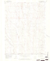
1965 Map of Huey Ranch
USGS Topo · Published 1967About this map
Huey Ranch and Redless Ranch serve as primary landmarks in this mid-1960s survey of the high plains where Morgan, Adams, and Washington Counties meet. The landscape is defined by the sweeping elevation of Pleasant Ridge and the drainage of Badger Creek, which cuts through the southwestern corner of the quadrangle. Local infrastructure during this era was centered on resource extraction and livestock, evidenced by the Sand River Oil Field and numerous scattered Oil Well sites. Transport across the arid terrain relies on a network of straight-line tracks like Seventeenmile Road and Badger Creek Road, alongside a prominent Pipeline that traverses the northern and central sections. Isolated markers such as Toyne Windmill, Windbreak Windmill, and the settlement of Frazier provide essential navigational points for researchers tracing the historical land use and early energy development of this corner of Colorado.
Find a feature on this map
17 named features on this map. Tap any name to fly to it.
Don’t see what you’re looking for? This feature index may not catch every label — zoom into the map to look around manually.
Map Details
Editions of this 1965 Huey Ranch Map
3 editions found
Other maps of this area

1954 · Limon
USGS Topo · 1:250,000

1954 · Sterling
USGS Topo · 1:250,000

1957 · Limon
USGS Topo · 1:250,000

1958 · Limon
USGS Topo · 1:250,000

1958 · Sterling
USGS Topo · 1:250,000

1963 · Lamb
USGS Topo · 1:24,000

1963 · Round Top
USGS Topo · 1:24,000

1965 · Gary
USGS Topo · 1:24,000

1965 · Vallery SE
USGS Topo · 1:24,000

1965 · Huey Ranch
USGS Topo · 1:24,000