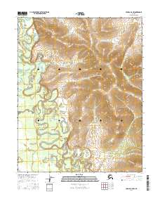
2016 Map of Hughes A-5 NW
USGS Topo · Published 2016About this map
Hogatza River dominates this interior Alaska landscape, weaving a complex network of oxbows and seasonal channels across the lowland valley. The waterway serves as the primary geographical anchor for the region, joined by smaller tributaries such as Caribou Creek and High Cr in the southern reaches. To the east, the terrain shifts as the drainage of Babataltin Cr cuts through the more elevated ground. This 2016 survey reflects a vast, undeveloped territory defined by its hydrologic patterns and the Public Land Survey System grids, including t9n r16e, which provide the only formal structure in an area otherwise shaped entirely by natural water cycles.
Find a feature on this map
10 named features on this map. Tap any name to fly to it.
Don’t see what you’re looking for? This feature index may not catch every label — zoom into the map to look around manually.
Map Details
Editions of this 2016 Hughes A-5 NW Map
This is the sole edition of this map. No revisions or reprints were ever made.
Other maps of this area

1951 · Hughes
USGS Topo · 1:250,000

1956 · Hughes
USGS Topo · 1:250,000

1964 · Hughes
USGS Topo · 1:250,000

1965 · Hughes
USGS Topo · 1:250,000
1986 · Hughes A-6
USGS Topo · 1:63,360
1986 · Hughes B-5
USGS Topo · 1:63,360
1986 · Hughes A-5
USGS Topo · 1:63,360
1986 · Hughes B-6
USGS Topo · 1:63,360
2016 · Hughes B-6 SE
USGS Topo · 1:25,000
2016 · Hughes A-6 NE
USGS Topo · 1:25,000