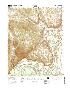
2016 Map of Hughes B-1 NW
USGS Topo · Published 2016About this map
The Koyukuk River dominates this interior landscape as it winds through the southern portion of the quadrangle, creating a series of dramatic bends and oxbows. These water features define the local geography, particularly where the river bypasses Lake Nogrilenten, a significant body of water situated in the lowlands. The surrounding terrain is marked by several drainages, including Discovery Cr and Henry Cr, which feed into the primary river system. This 2016 survey highlights a largely natural environment, characterized by the shifting patterns of the riverbed and the complex network of wetlands that follow its course. The lack of named roads or established settlements on this sheet suggests a region where movement is largely dictated by these waterways and the seasonal conditions of the Yukon-Koyukuk interior.
Find a feature on this map
10 named features on this map. Tap any name to fly to it.
Don’t see what you’re looking for? This feature index may not catch every label — zoom into the map to look around manually.
Map Details
Editions of this 2016 Hughes B-1 NW Map
This is the sole edition of this map. No revisions or reprints were ever made.
Other maps of this area

1951 · Hughes
USGS Topo · 1:250,000

1956 · Hughes
USGS Topo · 1:250,000

1964 · Hughes
USGS Topo · 1:250,000

1965 · Hughes
USGS Topo · 1:250,000
1986 · Hughes B-1
USGS Topo · 1:63,360
1986 · Hughes B-2
USGS Topo · 1:63,360
1986 · Hughes C-1
USGS Topo · 1:63,360
1986 · Hughes C-2
USGS Topo · 1:63,360
2016 · Hughes B-2 NE
USGS Topo · 1:25,000
2016 · Hughes C-1 SW
USGS Topo · 1:25,000