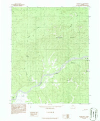
1986 Map of Hughes B-2
USGS Topo · Published 1986About this map
The Koyukuk River dominates this interior Alaska landscape, winding through a corridor of silt and water that includes Honeymoon Slough and Curve Slough. This 1980s-era topographical survey, compiled from early 1970s aerial photography, reveals a wilderness largely defined by its drainage patterns and prominent summits. To the north, the massive Niitltoktalogi Mountain stands as a primary landmark, while the southwestern portion of the sheet is marked by the distinct elevation of Red Mountain. The river's influence on the local geography is evident in the presence of Waite Island and Dog Island, which break the main channel. Smaller tributaries like Hughes Creek and Discovery Creek feed the larger system, cutting through the varied elevations of Shannon Hill and Mount George. This map captures the region's hydrography and terrain before significant modern changes, providing a clear record of the river's path and its relationship to the surrounding peaks.
Find a feature on this map
12 named features on this map. Tap any name to fly to it.
Don’t see what you’re looking for? This feature index may not catch every label — zoom into the map to look around manually.
Map Details
Editions of this 1986 Hughes B-2 Map
This is the sole edition of this map. No revisions or reprints were ever made.
Other maps of this area

1951 · Hughes
USGS Topo · 1:250,000

1955 · Hughes A-2
USGS Topo · 1:63,360

1955 · Hughes A-1
USGS Topo · 1:63,360

1955 · Hughes A-3
USGS Topo · 1:63,360

1956 · Hughes
USGS Topo · 1:250,000
1956 · Hughes A-3
USGS Topo · 1:63,360
1956 · Hughes A-2
USGS Topo · 1:63,360

1964 · Hughes
USGS Topo · 1:250,000

1965 · Hughes
USGS Topo · 1:250,000
1986 · Hughes B-1
USGS Topo · 1:63,360