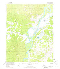
1956 Map of Hughes A-3
USGS Topo · Published 1974About this map
Hughes sits at the heart of this mid-century interior Alaska landscape, situated where the Koyukuk River bends through the valley. The settlement is clearly defined by its essential infrastructure of the era, including a Landing Strip and a Gaging Sta for monitoring the powerful river system. This terrain is defined by the convergence of major waterways, where the Hatdolitna River flows through Hatdolitna Canyon to meet the Koyukuk, creating a complex network of wetlands and oxbows like Long Bend and Long Slough.
Find a feature on this map
23 named features on this map. Tap any name to fly to it.
Don’t see what you’re looking for? This feature index may not catch every label — zoom into the map to look around manually.
Map Details
Editions of this 1956 Hughes A-3 Map
3 editions found
Other maps of this area

1951 · Hughes
USGS Topo · 1:250,000

1951 · Melozitna
USGS Topo · 1:250,000

1952 · Melozitna D-3
USGS Topo · 1:63,360

1954 · Melozitna D-4
USGS Topo · 1:63,360

1954 · Melozitna D-3
USGS Topo · 1:63,360

1955 · Melozitna D-2
USGS Topo · 1:63,360

1955 · Hughes A-2
USGS Topo · 1:63,360

1955 · Hughes A-3
USGS Topo · 1:63,360

1956 · Hughes
USGS Topo · 1:250,000

1956 · Melozitna
USGS Topo · 1:250,000