
1954 Map of Melozitna D-3
USGS Topo · Published 1963About this map
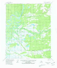
The Koyukuk River and its intricate network of waterways dominate this interior Alaska landscape as it was documented in the early 1950s. The presence of the Fishing Camp (2 Miles) and several scattered Cabins along the riverbanks highlights the importance of seasonal subsistence and travel along the water. The intricate drainage patterns of Huggins Slough and Mathew Slough illustrate the dynamic nature of the floodplain, where land and water merge into extensive wetlands. Further inland, Pocahontas Hot Springs and Pocahontas Creek mark a geologically distinct area, while surveying markers such as Canoe E Base and Dian provide the primary fixed points in an otherwise untamed wilderness. The map captures a moment before significant development, when the Indian River and its tributaries were the primary landmarks for navigators of the northern interior.
Find a feature on this map
14 named features on this map. Tap any name to fly to it.
Don’t see what you’re looking for? This feature index may not catch every label — zoom into the map to look around manually.
Map Details
Editions of this 1954 Melozitna D-3 Map
2 editions found
Other maps of this area

1951 · Hughes
USGS Topo · 1:250,000

1951 · Melozitna
USGS Topo · 1:250,000

1952 · Melozitna D-3
USGS Topo · 1:63,360

1954 · Melozitna C-4
USGS Topo · 1:63,360

1954 · Melozitna D-4
USGS Topo · 1:63,360

1954 · Melozitna C-3
USGS Topo · 1:63,360

1955 · Melozitna D-2
USGS Topo · 1:63,360

1955 · Hughes A-2
USGS Topo · 1:63,360

1955 · Hughes A-3
USGS Topo · 1:63,360

1956 · Hughes
USGS Topo · 1:250,000