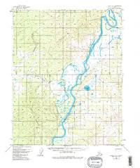
1956 Map of Hughes A-3
USGS Topo · Published 1982About this map
Hughes sits along the banks of the Koyukuk River in the mid-1950s, serving as a focal point for aviation and river transport in this interior Alaskan landscape. The settlement is anchored by a landing strip and protected by the looming presence of Hughes Mountain to the west. This period of development is marked by a clear corporate boundary surrounding the townsite, suggesting its status as an established community during a time when much of the territory remained unsurveyed.
Find a feature on this map
21 named features on this map. Tap any name to fly to it.
Don’t see what you’re looking for? This feature index may not catch every label — zoom into the map to look around manually.
Map Details
Editions of this 1956 Hughes A-3 Map
3 editions found
Other maps of this area

1951 · Hughes
USGS Topo · 1:250,000

1951 · Melozitna
USGS Topo · 1:250,000

1952 · Melozitna D-3
USGS Topo · 1:63,360

1954 · Melozitna D-4
USGS Topo · 1:63,360

1954 · Melozitna D-3
USGS Topo · 1:63,360

1955 · Melozitna D-2
USGS Topo · 1:63,360

1955 · Hughes A-2
USGS Topo · 1:63,360

1955 · Hughes A-3
USGS Topo · 1:63,360

1956 · Hughes
USGS Topo · 1:250,000

1956 · Melozitna
USGS Topo · 1:250,000