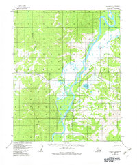
1956 Map of Hughes A-3
USGS Topo · Published 1982About this map
Hughes sits along the west bank of the Koyukuk River, serving as a central point of settlement in this sub-arctic landscape of the mid-1950s. The village is defined by its proximity to the water and its essential infrastructure, including a Landing Strip and a Gaging Sta to monitor the river's flow. Transport through the surrounding Hatdolitna Hills and toward Hughes Mountain relies on a network of Sled Trails, reflecting the seasonal logistics of the Yukon-Koyukuk region.
Find a feature on this map
21 named features on this map. Tap any name to fly to it.
Don’t see what you’re looking for? This feature index may not catch every label — zoom into the map to look around manually.
Map Details
Editions of this 1956 Hughes A-3 Map
3 editions found
Other maps of this area

1951 · Hughes
USGS Topo · 1:250,000

1951 · Melozitna
USGS Topo · 1:250,000

1952 · Melozitna D-3
USGS Topo · 1:63,360

1954 · Melozitna D-4
USGS Topo · 1:63,360

1954 · Melozitna D-3
USGS Topo · 1:63,360

1955 · Melozitna D-2
USGS Topo · 1:63,360

1955 · Hughes A-2
USGS Topo · 1:63,360

1955 · Hughes A-3
USGS Topo · 1:63,360

1956 · Hughes
USGS Topo · 1:250,000

1956 · Melozitna
USGS Topo · 1:250,000