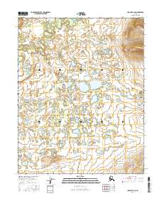
2016 Map of Hughes B-4 SE
USGS Topo · Published 2016About this map
Hogatza Flats dominates this portion of the Yukon-Koyukuk region, revealing an intricate landscape of interior Alaskan wetlands and wandering watercourses. The 2016 survey documents the shifting hydrography of the Hogatza River and Tallinkho Cr as they thread through a dense network of unnamed ponds and marshes. To the east, the terrain rises toward the base of the ridges surrounding Twin Lakes, contrasting the low-lying basin to the west. Central to this map is Lake Kyikhgyit, a prominent water body in a region defined by its seasonal drainage patterns. The southern reaches are marked by the flow of Koskatantna Cr, illustrating the complex watershed typical of the Koyukuk basin where water levels and channels are in constant transition.
Find a feature on this map
10 named features on this map. Tap any name to fly to it.
Don’t see what you’re looking for? This feature index may not catch every label — zoom into the map to look around manually.
Map Details
Editions of this 2016 Hughes B-4 SE Map
This is the sole edition of this map. No revisions or reprints were ever made.
Other maps of this area

1951 · Hughes
USGS Topo · 1:250,000

1955 · Hughes A-3
USGS Topo · 1:63,360

1956 · Hughes
USGS Topo · 1:250,000
1956 · Hughes A-3
USGS Topo · 1:63,360

1964 · Hughes
USGS Topo · 1:250,000

1965 · Hughes
USGS Topo · 1:250,000
1986 · Hughes B-4
USGS Topo · 1:63,360
1986 · Hughes B-3
USGS Topo · 1:63,360
1986 · Hughes A-4
USGS Topo · 1:63,360
2016 · Hughes A-4 NE
USGS Topo · 1:25,000