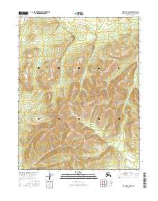
2016 Map of Hughes C-6 NW
USGS Topo · Published 2016About this map
Lockwood Hills dominate the southern half of this landscape in the Northwest Arctic Borough of Alaska, as documented in this 2016 survey. The terrain is characterized by complex contouring that reveals a series of prominent peaks and high ridges, with the elevation rising significantly from the northern lowlands. In the north-central portion of the map, the headwaters of Kokumpat Cr emerge from the slopes, carving a narrow drainage through the higher ground. The land is organized within a grid of several townships including t16n r13e, t15n r14e, and t14n r13e. This map provides a detailed view of the remote interior wilderness before more recent geological or ecological shifts, showing a landscape defined by its topography rather than permanent human settlements.
Find a feature on this map
8 named features on this map. Tap any name to fly to it.
Don’t see what you’re looking for? This feature index may not catch every label — zoom into the map to look around manually.
Map Details
Editions of this 2016 Hughes C-6 NW Map
This is the sole edition of this map. No revisions or reprints were ever made.
Other maps of this area

1951 · Shungnak
USGS Topo · 1:250,000

1951 · Hughes
USGS Topo · 1:250,000

1955 · Shungnak
USGS Topo · 1:250,000

1956 · Hughes
USGS Topo · 1:250,000

1964 · Shungnak
USGS Topo · 1:250,000

1964 · Hughes
USGS Topo · 1:250,000

1965 · Hughes
USGS Topo · 1:250,000
1985 · Shungnak D-1
USGS Topo · 1:63,360
1985 · Shungnak C-1
USGS Topo · 1:63,360
1986 · Hughes D-6
USGS Topo · 1:63,360