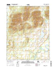
2016 Map of Hughes D-2 NE
USGS Topo · Published 2016About this map
The Alatna River meanders through the southern reaches of this landscape, its wide oxbows and channels contrasting with the steep, high-elevation terrain to the north. These northern highlands, defined by the townships of t19n r24e and t18n r24e, are drained by the headwaters of Helpmejack Creek and its smaller tributary labeled Helpmejack Cr. Between the sharp mountain ridges and the river valley lie the Helpmejack Lakes, a cluster of water bodies situated in a low basin that collects drainage before it reaches the main river system. This 2016 survey illustrates the transition from high-relief interior mountains to the complex, water-logged floodplains characteristic of the Yukon-Koyukuk region.
Find a feature on this map
10 named features on this map. Tap any name to fly to it.
Don’t see what you’re looking for? This feature index may not catch every label — zoom into the map to look around manually.
Map Details
Editions of this 2016 Hughes D-2 NE Map
This is the sole edition of this map. No revisions or reprints were ever made.
Other maps of this area

1951 · Hughes
USGS Topo · 1:250,000

1951 · Survey Pass
USGS Topo · 1:250,000

1956 · Hughes
USGS Topo · 1:250,000

1956 · Survey Pass
USGS Topo · 1:250,000

1964 · Survey Pass
USGS Topo · 1:250,000

1964 · Hughes
USGS Topo · 1:250,000

1965 · Hughes
USGS Topo · 1:250,000

1966 · Survey Pass
USGS Topo · 1:250,000
1986 · Hughes D-1
USGS Topo · 1:63,360
1986 · Survey Pass A-1
USGS Topo · 1:63,360