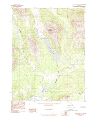
1986 Map of Survey Pass A-1
USGS Topo · Published 1986About this map
Iniakuk Lake occupies the central valley of this remote subarctic landscape, bordered to the north by Mount Hal Waugh. This 1986 provisional survey, based on photography from the early 1970s, documents a wilderness defined by its complex drainage systems and the Kateel River Meridian Boundary running along its eastern edge. The Alatna River and Iniakuk River dominate the lowlands, creating intricate meanders and marshy basins such as those near the Malamute Fork. To the south, the Alatna Hills rise above the river plains, while numerous smaller waterways like Tobuk Creek and Cummings Creek drain the surrounding heights. The lack of any roads or trails on the sheet emphasizes the purely topographical nature of the region during this era, serving as a primary record for those studying the hydrologic patterns and landforms of the Yukon-Koyukuk region.
Find a feature on this map
11 named features on this map. Tap any name to fly to it.
Don’t see what you’re looking for? This feature index may not catch every label — zoom into the map to look around manually.
Map Details
Editions of this 1986 Survey Pass A-1 Map
This is the sole edition of this map. No revisions or reprints were ever made.
Other maps of this area

1951 · Hughes
USGS Topo · 1:250,000

1951 · Bettles
USGS Topo · 1:250,000

1951 · Survey Pass
USGS Topo · 1:250,000

1951 · Wiseman
USGS Topo · 1:250,000

1956 · Hughes
USGS Topo · 1:250,000

1956 · Bettles
USGS Topo · 1:250,000

1956 · Wiseman
USGS Topo · 1:250,000

1956 · Survey Pass
USGS Topo · 1:250,000

1964 · Survey Pass
USGS Topo · 1:250,000

1964 · Wiseman
USGS Topo · 1:250,000