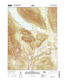
2016 Map of Hughes D-4 NE
USGS Topo · Published 2016About this map
Gates of the Arctic National Preserve encompasses a significant portion of this landscape, where the high elevation of the Akolikruich Hills meets the hydrology of the Brooks Range foothills. The northern portion of the map is dominated by the deep waters of Nutuvukti Lake, a notable feature that drains southward toward the winding path of the Kobuk River. This river corridor serves as a primary environmental artery through the Northwest Arctic, illustrating the transition from steep mountainous contours to the alluvial lowlands. Surveyed by the U.S. Geological Survey using modern imagery, the map provides a precise look at the township and range lines, including t18n r19e and t18n r20e, which help define these remote public lands.
Find a feature on this map
9 named features on this map. Tap any name to fly to it.
Don’t see what you’re looking for? This feature index may not catch every label — zoom into the map to look around manually.
Map Details
Editions of this 2016 Hughes D-4 NE Map
This is the sole edition of this map. No revisions or reprints were ever made.
Other maps of this area

1951 · Hughes
USGS Topo · 1:250,000

1951 · Survey Pass
USGS Topo · 1:250,000

1956 · Hughes
USGS Topo · 1:250,000

1956 · Survey Pass
USGS Topo · 1:250,000

1964 · Survey Pass
USGS Topo · 1:250,000

1964 · Hughes
USGS Topo · 1:250,000

1965 · Hughes
USGS Topo · 1:250,000

1966 · Survey Pass
USGS Topo · 1:250,000
1986 · Survey Pass A-4
USGS Topo · 1:63,360
1986 · Hughes D-4
USGS Topo · 1:63,360