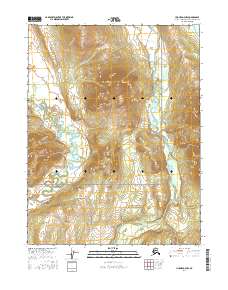
2016 Map of Hughes D-4 NW
USGS Topo · Published 2016About this map
Gates of the Arctic National Preserve covers the southern portion of this landscape, marking a protected wilderness where the northern boreal forest meets the Brooks Range. The hydrology is dominated by the Reed River, which winds southward through a broad glacial valley, and Beaver Creek, which drains the western reaches of the quadrangle. In the northeast corner, the southern tip of Nutuvukti Lake sits near the base of the mountains, a significant landmark in this remote subarctic environment. The map details the complex topography of high ridges and drainage basins that define this region of the Northwest Arctic Borough during the early 21st century.
Find a feature on this map
10 named features on this map. Tap any name to fly to it.
Don’t see what you’re looking for? This feature index may not catch every label — zoom into the map to look around manually.
Map Details
Editions of this 2016 Hughes D-4 NW Map
This is the sole edition of this map. No revisions or reprints were ever made.
Other maps of this area

1951 · Hughes
USGS Topo · 1:250,000

1951 · Survey Pass
USGS Topo · 1:250,000

1956 · Hughes
USGS Topo · 1:250,000

1956 · Survey Pass
USGS Topo · 1:250,000

1964 · Survey Pass
USGS Topo · 1:250,000

1964 · Hughes
USGS Topo · 1:250,000

1965 · Hughes
USGS Topo · 1:250,000

1966 · Survey Pass
USGS Topo · 1:250,000
1986 · Survey Pass A-5
USGS Topo · 1:63,360
1986 · Survey Pass A-4
USGS Topo · 1:63,360