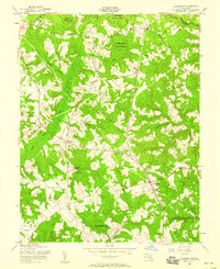
1956 Map of Hughesville
USGS Topo · Published 1958About this map
Cedarville State Forest dominates the northern landscape of this Southern Maryland region, its wooded expanse broken by the wetlands of Zekiah Swamp and Jordan Swamp. The mid-1950s settlement pattern reflects a deeply rooted community structure centered around crossroads and institutions. Education and faith are central to the geography here, with St Peters Ch and St Peters Sch in the north and the cluster of St Marys Sch and Notre Dame High Sch near Bryantown. The transit of the U S Government RR cuts a straight line through the forest, serving military interests of the era, while local commerce is marked by traditional names like Burnt Store and Grosstown. The southern portion transitions into the drainage basins of Swanson Creek and Gilbert Creek, showing a rural environment just before modern suburban expansion began to reach this part of Charles County.
Find a feature on this map
40 named features on this map. Tap any name to fly to it.
Don’t see what you’re looking for? This feature index may not catch every label — zoom into the map to look around manually.
Map Details
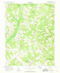
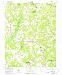
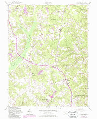
Editions of this 1956 Hughesville Map
4 editions found
Other maps of this area

1892 · Leonardtown
USGS Topo · 1:62,500

1892 · Prince Frederick
USGS Topo · 1:62,500

1892 · Brandywine
USGS Topo · 1:62,500

1894 · Wicomico
USGS Topo · 1:62,500

1895 · Prince Frederick
USGS Topo · 1:62,500

1895 · Wicomico
USGS Topo · 1:62,500

1895 · Brandywine
USGS Topo · 1:62,500

1895 · Leonardtown
USGS Topo · 1:62,500

1895 · Nomini
USGS Topo · 1:125,000

1898 · Nomini
USGS Topo · 1:125,000