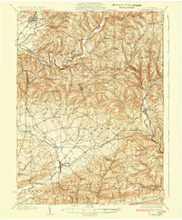
1935 Map of Hughesville
USGS Topo · Published 1935About this map
Hughesville serves as a primary hub in the northwest corner of this landscape, where the W & N B RR tracks follow the course of Muncy Creek. The terrain is defined by a dense network of small rural schoolhouses that supported isolated farming communities during the 1930s, including German Sch, Frenchtown Sch, and Clayhole Sch. These local institutions, alongside churches like Hendrickson Ch and Longs Ch, reveal the social fabric of the townships before modern school consolidation and road improvements shifted the rural population centers.
Find a feature on this map
90 named features on this map. Tap any name to fly to it.
Don’t see what you’re looking for? This feature index may not catch every label — zoom into the map to look around manually.
Map Details
Editions of this 1935 Hughesville Map

Other maps of this area

1889 · Catawissa
USGS Topo · 1:62,500

1892 · Catawissa
USGS Topo · 1:62,500

1892 · Shamokin
USGS Topo · 1:62,500

1893 · Sunbury
USGS Topo · 1:62,500

1893 · Shamokin
USGS Topo · 1:62,500

1894 · Catawissa
USGS Topo · 1:62,500

1894 · Bloomsburg
USGS Topo · 1:62,500

1924 · Milton
USGS Topo · 1:62,500

1927 · Eagles Mere
USGS Topo · 1:48,000

1930 · Warrensville
USGS Topo · 1:62,500