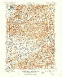
1953 Map of Hughesville
USGS Topo · Published 1956About this map
Hughesville serves as the primary hub in this mid-century portrait of north-central Pennsylvania, where the borders of Lycoming, Columbia, Montour, and Northumberland counties converge. The landscape is defined by the winding course of Muncy Creek and Chillisquaque Creek, with numerous small rural settlements like Lairdsville, Unityville, and Millville linked by a dense network of local roads.
Find a feature on this map
71 named features on this map. Tap any name to fly to it.
Don’t see what you’re looking for? This feature index may not catch every label — zoom into the map to look around manually.
Map Details
Editions of this 1953 Hughesville Map

Other maps of this area

1889 · Catawissa
USGS Topo · 1:62,500

1892 · Catawissa
USGS Topo · 1:62,500

1892 · Shamokin
USGS Topo · 1:62,500

1893 · Sunbury
USGS Topo · 1:62,500

1893 · Shamokin
USGS Topo · 1:62,500

1894 · Catawissa
USGS Topo · 1:62,500

1894 · Bloomsburg
USGS Topo · 1:62,500

1924 · Milton
USGS Topo · 1:62,500

1927 · Eagles Mere
USGS Topo · 1:48,000

1930 · Warrensville
USGS Topo · 1:62,500