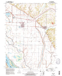
1993 Map of Hull
USGS Topo · Published 1996About this map
The Mississippi River forms the western boundary of this landscape, where the floodplain is defined by an intricate system of drainage and diversion structures. Managed water features like the Hadley-MC Craney Diversion Ditch and the Pigeon Creek Settling Basin reveal the complex engineering required to reclaim the lowlands for agriculture and settlement. Near the town of Hull, the terrain is marked by a grid of canals and roads, while to the east, the bluffs of Kinderhook and Barry provide a stark topographical contrast. Local history is anchored by several burial grounds including Hull Cem and House Cem, alongside industrial markers like the Quarry near Kinderhook. The presence of Lock and Dam No 22 and numerous named lakes like Broad Apron Lake and Pin Oak Lake highlights the enduring relationship between the river's flow and the communities of Pleasant Vale.
Find a feature on this map
48 named features on this map. Tap any name to fly to it.
Don’t see what you’re looking for? This feature index may not catch every label — zoom into the map to look around manually.
Map Details
Editions of this 1993 Hull Map
This is the sole edition of this map. No revisions or reprints were ever made.
Other maps of this area

1925 · Quincy
USGS Topo · 1:62,500

1925 · Liberty
USGS Topo · 1:62,500

1927 · Liberty
USGS Topo · 1:62,500

1931 · Barry
USGS Topo · 1:62,500

1932 · Hannibal
USGS Topo · 1:62,500

1936 · Hannibal
USGS Topo · 1:48,000

1936 · Barry
USGS Topo · 1:48,000

1944 · Barry
USGS Topo · 1:62,500

1944 · Quincy
USGS Topo · 1:62,500

1945 · Hannibal
USGS Topo · 1:62,500