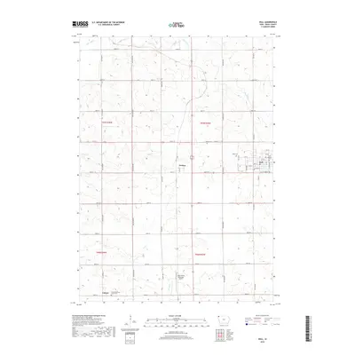
2018 Map of Hull
USGS Topo · Published 2018About this map
The town of Hull serves as the primary population center in this Sioux County landscape, defined by a rigid section-line road grid and the meandering paths of Burr Oak Cr and Rogg Cr. The map illustrates a established agricultural pattern where small settlements like Perkins and Carmel anchor the rural infrastructure. Local genealogy is well-documented through several burial sites, including the Pioneer Cem and Hope Cem, along with the Carmel Reformed Church Cem to the south. The southern portion of the quadrangle also features the Sioux Center Municipal Airport, reflecting the region's modern transportation needs alongside its traditional farming roots. The grid of avenues—from Garfield Ave to Hickory Ave—organizes the prairie into distinct sections, punctuated by the small residential blocks and named streets of Hull.
Find a feature on this map
47 named features on this map. Tap any name to fly to it.
Don’t see what you’re looking for? This feature index may not catch every label — zoom into the map to look around manually.
Map Details
Editions of this 2018 Hull Map
This is the sole edition of this map. No revisions or reprints were ever made.
Other maps of this area

1955 · Sioux Falls
USGS Topo · 1:250,000

1958 · Sioux Falls
USGS Topo · 1:250,000

1964 · Orange City
USGS Topo · 1:24,000

1964 · Boyden
USGS Topo · 1:24,000

1964 · Sioux Center
USGS Topo · 1:24,000

1964 · Hull
USGS Topo · 1:24,000

1968 · Labanon
USGS Topo · 1:24,000
1968 · Rock Valley
USGS Topo · 1:24,000

1971 · George West
USGS Topo · 1:24,000

1971 · Doon
USGS Topo · 1:24,000