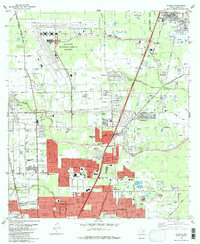
1982 Map of Humble
USGS Topo · Published 1982About this map
The massive footprint of Houston Intercontinental Airport dominates the northwest corner of this 1982 survey, its runways and Control Tower serving as a modern anchor for the rapidly expanding suburban landscape north of Houston. Surrounding the airfield, the map documents a transition from the old rail-and-bayou economy to modern aviation and residential growth. Long-standing communities like Bordersville and Humble sit alongside developing residential tracts in Parkwood Estates and Greenwood Village, while the industrial legacy of the region is visible in the numerous Oil Wells scattered near Dyersdale and along the Southern Pacific tracks.
Find a feature on this map
64 named features on this map. Tap any name to fly to it.
Don’t see what you’re looking for? This feature index may not catch every label — zoom into the map to look around manually.
Map Details
Editions of this 1982 Humble Map
This is the sole edition of this map. No revisions or reprints were ever made.
Other maps of this area

1915 · Houston Heights
USGS Topo · 1:24,000

1916 · Aldine
USGS Topo · 1:24,000

1916 · Settegast
USGS Topo · 1:24,000

1916 · Fauna
USGS Topo · 1:24,000

1916 · Harmaston
USGS Topo · 1:24,000

1916 · Moonshine Hill
USGS Topo · 1:24,000

1916 · Humble
USGS Topo · 1:24,000

1916 · Spring
USGS Topo · 1:24,000

1919 · Aldine
USGS Topo · 1:31,680

1919 · Humble
USGS Topo · 1:31,680