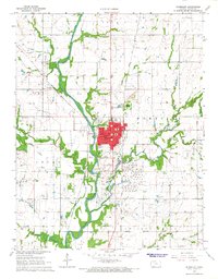
1966 Map of Humboldt
USGS Topo · Published 1967About this map
Humboldt serves as the focal point of this mid-1960s Allen County landscape, situated along a prominent bend of the Neosho River. The settlement's infrastructure is detailed through its municipal and social landmarks, including Cagnon Park, Riverside Park, and several local schools such as the High School and St Joseph School. The town's industrial and agricultural character is defined by the surrounding Oil Field, numerous Quarries, and the Missouri - Kansas - Texas and Atchison Topeka and Santa Fe railroad corridors that converge here.
Find a feature on this map
42 named features on this map. Tap any name to fly to it.
Don’t see what you’re looking for? This feature index may not catch every label — zoom into the map to look around manually.
Map Details
Editions of this 1966 Humboldt Map
2 editions found

Other maps of this area

1886 · Fredonia
USGS Topo · 1:125,000

1886 · Iola
USGS Topo · 1:125,000

1893 · Iola
USGS Topo · 1:125,000

1894 · Fredonia
USGS Topo · 1:125,000

1904 · Iola
USGS Topo · 1:125,000

1938 · Altoona
USGS Topo · 1:62,500

1939 · Altoona
USGS Topo · 1:48,000

1943 · Altoona
USGS Topo · 1:62,500

1947 · Joplin
USGS Topo · 1:250,000

1949 · Joplin
USGS Topo · 1:250,000