
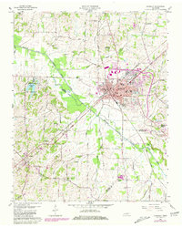
1959 Map of Humboldt
USGS Topo · Published 1960About this map
The Middle Fork Forked Deer River dominates the western landscape of this West Tennessee region, where the commercial hub of Humboldt serves as the focal point for three counties. In the late 1950s, the town's industrial and social infrastructure is well-defined, featuring the Gulf Mobile and Ohio and Louisville and Nashville railroads intersecting near the town center. Local education and community life are anchored by Stigall High Sch, the Humboldt Country Club, and several civic buildings including the Library and Hospital.
Find a feature on this map
67 named features on this map. Tap any name to fly to it.
Don’t see what you’re looking for? This feature index may not catch every label — zoom into the map to look around manually.
Map Details
Editions of this 1959 Humboldt Map
2 editions found
Other maps of this area

1950 · Jackson North
USGS Topo · 1:24,000

1951 · Jackson North
USGS Topo · 1:24,000

1951 · Trenton
USGS Topo · 1:24,000

1952 · Milan
USGS Topo · 1:24,000

1956 · Blytheville
USGS Topo · 1:250,000

1959 · Medina
USGS Topo · 1:24,000

1959 · Blytheville
USGS Topo · 1:250,000

1959 · Bells
USGS Topo · 1:24,000

1959 · Adair
USGS Topo · 1:24,000
1964 · Alamo
USGS Topo · 1:24,000