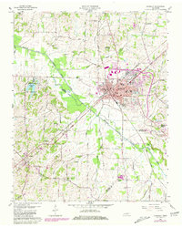
1959 Map of Humboldt
USGS Topo · Published 1981About this map
Humboldt sits at the junction of two major transit systems, where the Louisville and Nashville Railroad crosses the Illinois Central Gulf Railroad. This mid-century survey reveals a thriving agricultural and transport hub at the intersection of Gibson, Crockett, and Madison counties. The town core is dense with civic landmarks, including the Stigall High Sch, City Hall, and a Radio Tower (WIRJ), while the surrounding landscape is defined by the Middle Fork Forked Deer River. Rural life is documented through numerous family-named burial grounds like Newhouse Cem and Motley Cem, alongside small communities like Gadsden and Mason Grove. To the west, the State Reservation surrounding Humboldt Lake provides a contrast to the geometric grid of cotton and soybean fields that historically dominated this region of West Tennessee.
Find a feature on this map
66 named features on this map. Tap any name to fly to it.
Don’t see what you’re looking for? This feature index may not catch every label — zoom into the map to look around manually.
Map Details
Editions of this 1959 Humboldt Map
2 editions found
Other maps of this area

1950 · Jackson North
USGS Topo · 1:24,000

1951 · Jackson North
USGS Topo · 1:24,000

1951 · Trenton
USGS Topo · 1:24,000

1952 · Milan
USGS Topo · 1:24,000

1956 · Blytheville
USGS Topo · 1:250,000

1959 · Medina
USGS Topo · 1:24,000

1959 · Blytheville
USGS Topo · 1:250,000

1959 · Bells
USGS Topo · 1:24,000

1959 · Adair
USGS Topo · 1:24,000

1959 · Humboldt
USGS Topo · 1:24,000