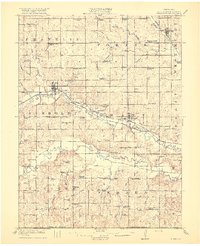
1916 Map of Humboldt
USGS Topo · Published 1916About this map
Humboldt and Stella serve as primary hubs in this agricultural landscape of Richardson County during the early twentieth century. The terrain is defined by the winding paths of the North Fork Nemaha River and South Fork Nemaha River, which are flanked by an extensive network of rural schoolhouses such as Windy Lonesome School and Cottage School. A distinctive engineering feature of the era is the Chicago Drainage Canal, running parallel to the North Fork Nemaha River near Dawson. Transportation is anchored by the Missouri Pacific RR in the north and the Chicago Burlington and Quincy RR traversing the center, facilitating the movement of grain and livestock from settlements like Nims City and the historic Miles Ranch. The map also preserves the locations of local landmarks like the Lynchburg Cemetery and numerous family-named branches like Porter Branch and Honey Creek.
Find a feature on this map
74 named features on this map. Tap any name to fly to it.
Don’t see what you’re looking for? This feature index may not catch every label — zoom into the map to look around manually.
Map Details
Editions of this 1916 Humboldt Map
3 editions found
Other maps of this area

1888 · Hiawatha
USGS Topo · 1:125,000

1889 · Seneca
USGS Topo · 1:125,000

1894 · Seneca
USGS Topo · 1:125,000

1894 · Hiawatha
USGS Topo · 1:125,000

1915 · Falls City
USGS Topo · 1:62,500

1915 · Nemaha
USGS Topo · 1:62,500

1915 · Howe
USGS Topo · 1:62,500

1916 · Humboldt
USGS Topo · 1:62,500

1939 · Nemaha
USGS Topo · 1:62,500

1949 · Nemaha
USGS Topo · 1:62,500